|
Weather
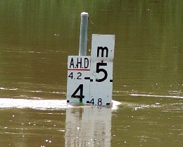
Links  Gympie Radar Loop (BOM) Weather Zone
|
Veteran
|
|
||||||||||||||||||||||||||||||||||||||||||||||||||||||||||||||||||||||||||||||||||||||||||||||||||||||||||||||||||||||||||||||||||||||||||||
|
GYMPIE and REGION: IDQ10240 Australian Government Bureau of Meteorology Queensland Wide Bay and Burnett District Forecast Issued at 4:15 pm EST on Thursday 8 May 2025 for the period until midnight EST Monday 12 May 2025. Warning Information For latest warnings go to www.bom.gov.au, subscribe to RSS feeds, call 1300 659 210* or listen for warnings on relevant TV and radio broadcasts. Weather Situation A firm ridge will persist over much of the state for the next several days, maintained by a high pressure system moving east across southern Australia and into the Tasman Sea by the weekend.d. A weak trough extending from the Arafura Sea to the far northern Coral Sea will linger for several days, and combine with the firm ridge to produce strong winds and rough seas along the Queensland east coast. The ridge and enhanced winds and seas will slowly decline in strength during next week. Forecast for the rest of Thursday 8 May Mostly clear. Slight chance of a shower along the coastal fringe, most likely later tonight. Near zero chance of rain elsewhere. Winds southeasterly 15 to 20 km/h. Forecast for Friday 9 May Partly cloudy. Medium chance of showers along the coastal fringe, slight chance elsewhere. Winds southeasterly 25 to 35 km/h. Overnight temperatures falling to between 12 and 18 with daytime temperatures reaching the low to mid 20s. Bundaberg Possible shower. Min 18 Max 25 Gayndah Partly cloudy. Min 14 Max 26 Gympie Shower or two. Min 16 Max 24 Hervey Bay Shower or two. Min 19 Max 25 Kingaroy Cloudy. Min 12 Max 21 Maryborough Shower or two. Min 18 Max 25 Fire Danger: Moderate Sun protection 9:10am to 2:20pm, UV Index predicted to reach 6 [High] Forecast for Saturday 10 May Partly cloudy. Medium chance of showers along the coastal fringe, slight chance elsewhere. Winds southeasterly 25 to 35 km/h. Overnight temperatures falling to between 11 and 17 with daytime temperatures reaching 20 to 25. Bundaberg Partly cloudy. Min 17 Max 25 Gayndah Partly cloudy. Min 14 Max 24 Gympie Shower or two. Min 16 Max 23 Hervey Bay Shower or two. Min 18 Max 25 Kingaroy Possible shower. Min 11 Max 19 Maryborough Possible shower. Min 17 Max 25 Forecast for Sunday 11 May Partly cloudy. High chance of showers about K'gari, medium chance elsewhere. Winds southeasterly 20 to 30 km/h becoming light during the evening. Overnight temperatures falling to between 11 and 17 with daytime temperatures reaching the low to mid 20s. Bundaberg Possible shower. Min 17 Max 25 Gayndah Partly cloudy. Min 14 Max 25 Gympie Shower or two. Min 15 Max 23 Hervey Bay Shower or two. Min 18 Max 25 Kingaroy Shower or two. Min 12 Max 21 Maryborough Shower or two. Min 17 Max 25 Forecast for Monday 12 May Partly cloudy. High chance of showers about K'gari, medium chance elsewhere. Light winds becoming southeasterly 15 to 25 km/h during the morning then becoming light during the evening. Overnight temperatures falling to between 12 and 17 with daytime temperatures reaching the low to mid 20s. Bundaberg Possible shower. Min 17 Max 26 Gayndah Possible shower. Min 14 Max 26 Gympie Shower or two. Min 15 Max 24 Hervey Bay Shower or two. Min 17 Max 25 Kingaroy Possible shower. Min 12 Max 21 Maryborough Shower or two. Min 16 Max 25 The next routine forecast will be issued at 5:00 am EST Friday. * Calls to 1300 numbers cost around 27.5c incl. GST, higher from mobiles or public phones. Copyright Commonwealth of Australia 2011, Bureau of Meteorology (ABN 92 637 533 532). Users of these web pages are deemed to have read and accepted the conditions described in the Copyright, Disclaimer, and Privacy statements (http://www.bom.gov.au/other/copyright.shtml). |
||||||||||||||||||||||||||||||||||||||||||||||||||||||||||||||||||||||||||||||||||||||||||||||||||||||||||||||||||||||||||||||||||||||||||||||
STATE FORECAST:IDQ10700 Australian Government Bureau of Meteorology Queensland Queensland State Forecast Issued at 4:30 pm EST on Thursday 8 May 2025 for the period until midnight EST Thursday 15 May 2025. Warning Information For latest warnings go to www.bom.gov.au, subscribe to RSS feeds, call 1300 659 210* or listen for warnings on relevant TV and radio broadcasts. Weather Situation A firm ridge will persist over much of the state for the next several days, maintained by a high pressure system moving east across southern Australia and into the Tasman Sea by the weekend.d. A weak trough extending from the Arafura Sea to the far northern Coral Sea will linger for several days, and combine with the firm ridge to produce strong winds and rough seas along the Queensland east coast. The ridge and enhanced winds and seas will slowly decline in strength during next week. Forecast for the rest of Thursday 8 May Partly cloudy in the far west and northern interior. Mostly clear elsewhere over interior Queensland. Isolated showers about the exposed coastal fringe, tending scattered about the Wet Tropics and widespread about the far northeastern Peninsula. Mostly clear in South East Queensland, with isolated to scattered showers developing about the coastal fringe. The chance of a thunderstorm about Cape York and Torres Strait Islands. Moderate south to southeasterly winds, fresh to strong at times about the east coast. Forecast for Friday 9 May Mostly sunny in the west with isolated showers over the interior east of about the Carnarvon Ranges to Hughenden. Isolated showers elsewhere, tending scattered about the east coast. Showers may tend widespread at times about the Wet Tropics and in Torres Strait, along with the exposed Southeast Coast. The chance of a thunderstorm about Torres Strait. Fresh to strong southeasterly winds about the east coast. Moderate to fresh southeasterly winds elsewhere. Maximum temperatures above average over inland southern Queensland, near or a little below average elsewhere. Forecast for Saturday 10 May Mostly sunny in the west, with isolated showers over the interior north of Winton and east of Dalby. Isolated showers elsewhere, tending scattered about the east coast and far northern Peninsula. Showers may tend widespread at times about the Wet Tropics and in Torres Strait, along with the exposed Southeast Coast. The chance of a thunderstorm about northern Torres Strait. Fresh to strong southeasterly winds about the east coast. Maximum temperatures near or slightly below average, tending above average in the far southwest. Forecast for Sunday 11 May Mostly sunny in the far southwest. Partly cloudy over the rest of the interior with isolated showers north of Boulia and east of Augathella. Isolated showers to scattered showers in eastern districts and the far north, tending widespread at times about the Wet Tropics and exposed Southeast Coast. The chance of a thunderstorm about Torres Strait. Fresh to strong southeasterly winds about the east coast. Maximum temperatures near or slightly below average. Forecast for Monday 12 May Partly cloudy in the far southwest, with isolated showers over the interior east of Charleville and Georgetown. Isolated to scattered showers in eastern districts and the far north. Showers possibly tending widespread at times about the Wet Tropics. The chance of a thunderstorm about Torres Strait. Fresh to strong southeasterly winds about the east coast. Maximum temperatures near average. Outlook for Tuesday 13 May to Thursday 15 May Partly cloudy in the far southwest, with isolated showers over the interior east of Cunnamulla and Georgetown, extending to most of the remaining interior from Wednesday. Isolated to scattered showers in eastern districts and the far north. The chance of a thunderstorm about Torres Strait until Thursday. Maximum temperatures near average, tending above average inland locally in southern and central Queensland. The next routine forecast will be issued at 4:30 am EST Friday. * Calls to 1300 numbers cost around 27.5c incl. GST, higher from mobiles or public phones. Copyright Commonwealth of Australia 2011, Bureau of Meteorology (ABN 92 637 533 532). Users of these web pages are deemed to have read and accepted the conditions described in the Copyright, Disclaimer, and Privacy statements (http://www.bom.gov.au/other/copyright.shtml). |
||||||||||||||||||||||||||||||||||||||||||||||||||||||||||||||||||||||||||||||||||||||||||||||||||||||||||||||||||||||||||||||||||||||||||||||
|
Ted's Comment... Wednesday, 26 March 2025 10:04
I have updated some important links, remember to have a look at the links on
the left of the page to see what is going on in our region... Ted Uebergang |
||||||||||||||||||||||||||||||||||||||||||||||||||||||||||||||||||||||||||||||||||||||||||||||||||||||||||||||||||||||||||||||||||||||||||||||
|
|
|
|
||||||||||||||||||||||||||||||||||||||||||||||||||||||||||||||||||||||||||||||||||||||||||||||||||||||||||||||||||||||||||||||||||||||||||||
|
|
|
|
||||||||||||||||||||||||||||||||||||||||||||||||||||||||||||||||||||||||||||||||||||||||||||||||||||||||||||||||||||||||||||||||||||||||||||
|
|
|
|
||||||||||||||||||||||||||||||||||||||||||||||||||||||||||||||||||||||||||||||||||||||||||||||||||||||||||||||||||||||||||||||||||||||||||||
|
|
||||||||||||||||||||||||||||||||||||||||||||||||||||||||||||||||||||||||||||||||||||||||||||||||||||||||||||||||||||||||||||||||||||||||||||||


